
Monday (10/31) Morning Weather Briefing
GOOD MORNING AND HAPPY HALLOWEEN!
We are wrapping up another warm month today, one that will end up about 5.5 degrees above average locally. Much of the lower 48 states had a warm October:

A nice Halloween today with high temperatures betwen 53-55. Lower 50s and upper 40s for trick-or-treaters this evening.

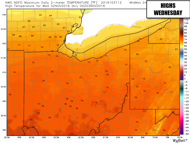
Another shot of unseasonably warm air is in the way as we start November. Check out these highs over the next couple of days:
Click to Enlarge

We will be dry both days.
NEXT RAIN CHANCE
No raindrops until very late Wednesday night into parts of Thursday with our next cold front. That front will put an end to the silly early November warmth.

Quiet weather will return for Friday and the weekend. No concerns for wet weather as of now.

The air mass behind the front will be cooler but certainly not much colder than average. Highs Friday through the weekend may even be somewhat warmer than shown on both of these models.


Notice the chilly numbers that show up in the longer range. We are expecting the overall weather pattern to start favoring colder air over warmer air as we head deeper into November. Notice how different the pattern looks now vs what we expect in 2 weeks:


No big deal, right? It’s SUPPOSED to get cold in November. Well yes. However there is a chance that BEYOND two weeks from now the pattern turns MUCH colder and stormier. Our winter forecast will include a potentially stormy, cold period from Thanksgiving through New Year’s. Speaking of which…..
WINTER FORECAST
This is the week! My Winter 2016-2017 forecast will likely debut on Thursday. Tune into 21 News and check out my blog/social media next week for details.
WEATHER FOR WEATHER GEEKS:
The Valley’s most detailed weather forecast is “Weather For Weather Geeks”! This evening’s video will be on ericwfmj.com and wfmj.com/weather as well as the StormTracker app by 8:00pm.
STORM TRACKER 21 STORM SPOTTERS
Interested in joining our closed spotter group on Facebook?? We prefer you be SKYWARN trained but some exceptions can be made. This group is a place to report severe weather or just chat about interesting weather across our region. Fill out this form if interested!
Storm Tracker 21 Spotter Sign Up Sheet
21 STORMTRACKER WEATHER APP
Head to your favorite app store and get the Valley’s most accurate forecast in your pocket!
CONNECT:
Weather For Weather Geeks October 27
Thursday (10/27) Morning Weather Briefing
MORNING!
A gloomy start to the day across the Valley but we are about done with the wettest part of the day. At least we are not shoveling it! Snow is falling this morning in New York and NE Pennsylvania.

Our hi-res futurecast shows the rain becoming hit/miss showers for the rest of the day:

Hourly rain chances:

Temperatures will peak in the mid 50s at midday then slowly fall with a gusty NW wind this afternoon.

Friday looks much better with increasing amounts of sunshine. Great afternoon to rake some leaves and a cool, crip evening for high school football.

THE WEEKEND
Here comes the warmth! Saturday looks downright balmy with highs in the upper 60s and a gusty wind. Not much more than a passing afternoon shower.


On Sunday, a very weak front will slowly sag south, leading to a chance for showers.

HALLOWEEN
Nothing scary about this forecast. A good deal of sun and seasonable temperatures expected.

Then, WOW a warm day Tuesday. I think we have a good chance at highs of 70-74 degrees. Break out the shorts on November 1!

LONG RANGE
Back to seasonable weather later next week.

2 DEGREE GUARANTEE

WINTER FORECAST
We are less than a week away from the issuance of my Winter 2016-2017 forecast. Tune into 21 News and check out my blog/social media next week.
WEATHER FOR WEATHER GEEKS:
The Valley’s most detailed weather forecast is “Weather For Weather Geeks”! This evening’s video will be on ericwfmj.com and wfmj.com/weather as well as the StormTracker app by 8:00pm.
STORM TRACKER 21 STORM SPOTTERS
Interested in joining our closed spotter group on Facebook?? We prefer you be SKYWARN trained but some exceptions can be made. This group is a place to report severe weather or just chat about interesting weather across our region. Fill out this form if interested!
Storm Tracker 21 Spotter Sign Up Sheet
21 STORMTRACKER WEATHER APP
Head to your favorite app store and get the Valley’s most accurate forecast in your pocket!
CONNECT:
Weather For Weather Geeks October 26
Wednesday (10/26) Morning Weather Briefing
GOOD MORNING!
Go Tribe!
A cold start this morning as expected; some places had temperatures below 30 at the start of the day.

It’s going to be a struggle in the temperatures department today as clouds slowly thicken. We’ll see highs in the upper 40s….well below average. Meanwhile, a warm front is off to our west:

Ominous, right? Well a lot of that rain in western Ohio is going to have a tough time reaching the ground in NE Ohio and western PA this afternoon, thanks to dry air in the low levels of the atmosphere. That said, we will have a 20% chance in the forecast for this afternoon as someone might see a shower or sprinkle.

Overall, dry through this evening then rain will push in overnight. Hi-res futurecast:

The start of game 2 has been moved up to 7:08 this evening, a good move although the latest model trends suggest that an 8:08 start may have been ok too. Rain chances will increase quickly in Cleveland after 11:00.

Rain will be around late tonight and tomorrow morning with spotty residual showers in the afternoon. Temperatures will slowly fall with a chilly breeze tomorrow afternoon.

Rain totals will average 0.3″-0.5″.

A better day Friday with a cool, pleasant evening for football.

The weekend looks to start on a breezy, warmer note with a southwest wind. We have temperatures in the 60s in our forecast. Might be a shower late.

That front may stall overhead Sunday, leading to a chance for showers.

LONG RANGE
Warm to start next week then a retreat back to average looks likely.

2 DEGREE GUARANTEE

WINTER FORECAST
We are about ONE week away from the issuance of my Winter 2016-2017 forecast. Stay tuned for an exact date!
WEATHER FOR WEATHER GEEKS:
The Valley’s most detailed weather forecast is “Weather For Weather Geeks”! This evening’s video will be on ericwfmj.com and wfmj.com/weather as well as the StormTracker app by 8:00pm.
STORM TRACKER 21 STORM SPOTTERS
Interested in joining our closed spotter group on Facebook?? We prefer you be SKYWARN trained but some exceptions can be made. This group is a place to report severe weather or just chat about interesting weather across our region. Fill out this form if interested!
Storm Tracker 21 Spotter Sign Up Sheet
21 STORMTRACKER WEATHER APP
Head to your favorite app store and get the Valley’s most accurate forecast in your pocket!
CONNECT:
Weather For Weather Geeks October 25
Tuesday (10/25) Morning Weather Briefing
GOOD TUESDAY MORNING….
An uneventful Fall day on tap for today with times of sunshine and times of clouds. A chilly one but not quite as blustery as yesterday.

The sky will be mainly clear to patrtly cloudy for part of the night tonight, allowing it turn colder. Temperatures would drop even lower if not for some clouds moving in late.

NO problems for Game 1 of the World Series in Cleveland tonight (other than it will be cold!). First pitch temperature in the upper 40s.

Notice the chance for rain for Game 2 on Wednesday. A warm front will be lifting across the region Wednesday. There may be a little afternoon and early evening rain but I dfon’t think that is a big deal.

What can be more problematic for the game is the steadier rain that will likely move in as the evening progresses.

So I can see a scenario where the game starts on time but there are delays later. Hopefully not a postponement.
Rain will be with us overnight Wednesday night into early Thursday. Thursday afternoon looks drier but it will be blustery with falling temperatures.

Rain totals of around 0.50-0.75″ are likely. I like the higher end of our computer model spread here:

FRIDAY AND SATURDAY
Friday will bring some sunshine back and it should be a nice, crisp evening for football.

A quick but impressive shot of warmth looks likely Saturday ahead of the next cold front. I can see where temperatures get well into the 60s with a gusty breeze. Looks like we will be lowering rain chances that day too.

LONG RANGE
Mild readings to wrap up October and start November. Looking at a colder pattern by the 2nd week of the month.


2 DEGREE GUARANTEE

WINTER FORECAST
We are about ONE week away from the issuance of my Winter 2016-2017 forecast. Stay tuned for an exact date!
WEATHER FOR WEATHER GEEKS:
The Valley’s most detailed weather forecast is “Weather For Weather Geeks”! This evening’s video will be on ericwfmj.com and wfmj.com/weather as well as the StormTracker app by 8:00pm.
STORM TRACKER 21 STORM SPOTTERS
Interested in joining our closed spotter group on Facebook?? We prefer you be SKYWARN trained but some exceptions can be made. This group is a place to report severe weather or just chat about interesting weather across our region. Fill out this form if interested!
Storm Tracker 21 Spotter Sign Up Sheet
21 STORMTRACKER WEATHER APP
Head to your favorite app store and get the Valley’s most accurate forecast in your pocket!
CONNECT:
Weather For Weather Geeks October 24
Monday Morning (10/24) Weather Briefing
GOOD MORNING!
It’s a new work week and we have plenty to talk about. After a beautiful Sunday, today will be “less nice” with clouds much of the day. Temperatures this morning are within a degree or two of 50 in most spots and temperatures this afternoon will be….pretty much the same. What you see is what you get today!


What about showers? I suspect most areas from Youngstown south and west will be dry. The farther north and east you go, the higher the likelihood of seeing a shower or two during the midday and afternoon. Some lake-effect rain shower activity, with a Lake Huron connection, will be aimed at far NE Ohio and NW PA.
Futurecast:

MIDWEEK
A brighter day coming up on Tuesday (with clouds perhaps stubborn to break in Mercer County) and with a clear sky Tuesday night we probably have our coldest night of the season so far on the way. Lows of 27-32 will be common.


Our next chance for wet weather will be Wednesday evening/night (with a warm front) and Thursday (with a cold front). Getting a little concerned about some wet weather for Game 2 of the World Series in Cleveland.


The wettest part of Thursday is likely to be in the morning. A gusty breeze all day.
FRIDAY+LONG RANGE
Friday looks good. Seasonably chilly for week 10 of high school football.

Rain probably returns with the next system on Saturday.
I think October will end and November will begin with a mild weather pattern. 6-10 day outlook:

WINTER FORECAST
We are about ONE week away from the issuance of my Winter 2016-2017 forecast. Stay tuned for an exact date!
WEATHER FOR WEATHER GEEKS:
The Valley’s most detailed weather forecast is “Weather For Weather Geeks”! This evening’s video will be on ericwfmj.com and wfmj.com/weather as well as the StormTracker app by 8:00pm.
STORM TRACKER 21 STORM SPOTTERS
Interested in joining our closed spotter group on Facebook?? We prefer you be SKYWARN trained but some exceptions can be made. This group is a place to report severe weather or just chat about interesting weather across our region. Fill out this form if interested!
Storm Tracker 21 Spotter Sign Up Sheet
21 STORMTRACKER WEATHER APP
Head to your favorite app store and get the Valley’s most accurate forecast in your pocket!
